


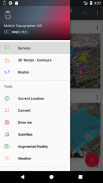
Mobile Topographer GIS


Mobile Topographer GIS का विवरण
पेशेवरों की प्रिय विकल्प है,
मोबाइल topographer ... को पूरा करता है ...
जीआईएस ।
अब आप जटिलता या डेटा की मात्रा में किसी भी सीमा के बिना एक पूरा सर्वेक्षण कर सकते हैं।
अब तीन दिन नि: शुल्क परीक्षण अवधि का उपयोग करके मोबाइल topographer जीआईएस का प्रयास करें। बस एप्लिकेशन डाउनलोड करने और वह सदस्यता प्रक्रिया के साथ आगे बढ़ें। हालांकि, आप बिलिंग जानकारी प्रदान करने को कहा जाएगा, तो आप निःशुल्क परीक्षण अवधि के तीन दिन के अंत से पहले चार्ज नहीं किये जाएंगे। आप नि: शुल्क तीन दिन परीक्षण अवधि के दौरान किसी भी समय अपनी सदस्यता रद्द कर सकते हैं। प्रभार केवल, तभी लागू होगा, तीन दिन के अंत में आप अभी भी सक्रिय सदस्यता है।
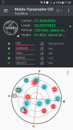
- वृद्धि की सटीकता का उपयोग कर GNSS रीडिंग एकत्र (जीपीएस, ग्लोनास, गैलिलियो, Beidou, QZSS तारामंडल समर्थित)।
- कृत्रिम स्थान के माध्यम से अपने बाहरी GNSS रिसीवर कनेक्ट और एक प्रोसेसिंग यूनिट के रूप में मोबाइल Topogrpaher जीआईएस का उपयोग करें।
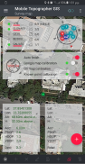
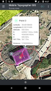
- WGS84 या आप स्थानीय अनुमान सीआरएस में प्रदर्शन डेटा।
स्थानीय सीआरएस का अनुमान है और इसके विपरीत करने के लिए WGS84 से कन्वर्ट -।
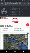
- मानचित्र पर वास्तविक समय प्रक्षेपण।
- *** नई *** कस्टम छवि या नक्शे पृष्ठभूमि के रूप में WMS सर्वर।
- का उपयोग करते हुए "मुझे डिस्क" से असली दुनिया में एक चिह्नित बिंदु का पता लगाएं
- मक्खी ईजीएम मॉडल या स्थानीय ऊंचाई ग्रिड जहां उपलब्ध का उपयोग करने पर गणना Orthometric ऊंचाई।
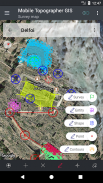
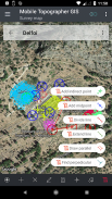
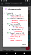
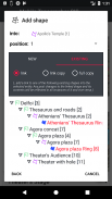
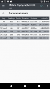
- आकार - - संस्थाओं और सर्वेक्षण अंक में अपने काम को व्यवस्थित करें। अब आप किसी विशेष अंक, बहु बिंदु समूहों, बहुखण्डीय पोलीलाइंस, और छेद के साथ बहुखण्डीय बहुभुज बना सकते हैं।
- के रूप में आप चाहते हैं के रूप में ज्यादा विवरण के साथ एक पूर्ण ड्रॉइंग बनाएं।
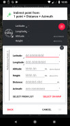
- *** नई *** जियोडेटिक उपकरण। निम्न विकल्पों में से पर के माध्यम से अप्रत्यक्ष अंक जोड़ें: 1 अंक + दूरी + दिगंश, 2 अंक + दूरियां + चुनें, 2 अंक + azimuths, 3 अंक + दूरियां, रेखा, फूट डालो पंक्ति का मध्यबिंदु, बढ़ाएँ लाइन, समानांतर रेखा, लम्ब के लिए ।
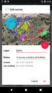
- नेस्ट अपनी नौकरी, किसी भी नेस्टिंग स्तर में, एक सुपर सर्वेक्षण बनाने के लिए।
- सक्रिय लिंक के साथ नौकरियों के बीच डेटा साझा करें।
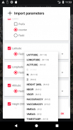
- अपने मोबाइल डिवाइस और अपने डेस्कटॉप कंप्यूटर के बीच आदान-प्रदान नौकरियों आयात के साथ - सभी आम स्वरूपों का उपयोग निर्यात कार्यों .txt, .csv, .kml, .gpx, .dxf और आकार फ़ाइलें (.shp - .shx - .dbf)
- का आदान प्रदान और नौकरियों को पूरा करने के एक बिंदु से साझा करके अपने सहयोगियों के साथ सहयोग करें।
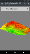
- बस इसे माध्यम से चलने से एक क्षेत्र के 3D भू-भाग बनाएँ।
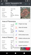
- आकृति की गणना करें और उन्हें बिजली की गति के साथ अपने सर्वेक्षण में जोड़ें।
- आपके डिवाइस में सीधे कोई वास्तविक 3 डी मॉडल देखें।
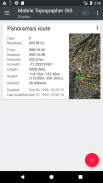
- उसके डेटा के साथ मार्ग संग्रहित करें।
- दोनों कंपास दृश्य या एआर में संकेत जानकारी के साथ GNSS दिखाएँ उपग्रहों।
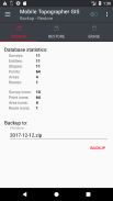
- बैकअप और एक SQL .db फ़ाइल का उपयोग कर अपने डेटा को पुनर्स्थापित।
मोबाइल सर्वेक्षण के युग में आपका स्वागत है ...!
मोबाइल topographer जीआईएस के बारे में अधिक जानकारी प्राप्त करें:
http://applicality.com/projects/mobile-topographer-gis/
से डाउनलोड करें उपयोगकर्ता मैनुअल:
http://applicality.com/app_documentation/web/MobileTopographerGIS_Manual.pdf


Mobile Topographer GIS - एपीके जानकारी
एपीके संस्करण: 6.0.15पैकेज: com.applicality.mobiletopographergisLatest Version of Mobile Topographer GIS
अन्य संस्करण


 4.34
4.34


Apps in the same category

You may also like...


